


Vancouver Neighbourhoods are an Endangered Species
City Conversation #61: Erased from the proposed Vancouver Plan, our city’s 23 neighbourhoods will be gone for good if we stay silent.

July 3, 2022—With the passage of the Broadway Plan, for better or worse, it’s time to move on to the next act in the Planning Department’s pre-election strategy. Introduced in final form just a week ago, the Plan comes before Council on July 6th —if passed it will quickly become our Official Community Plan (OCP).

The proposed Vancouver Plan’s land use strategy pays no attention to neighbourhoods
“They must be here somewhere!” I exclaimed to myself as I pored over the proposed Vancouver Plan, the final version of which only arrived in Council’s in-email one week before it’s to be considered for adoption on July 6th. I had attended a one hour media briefing the afternoon before the official unveil, on behalf of CityHallWatch, for whom I am a guest writer. Staff were looking to prime media a day in advance of tabling the document with City Council.
The “They” I was referring to as I perused the 166-page Plan was Vancouver’s 22 neighbourhoods. “After all,” I continued to myself, “16 of the 22 are included in the Acknowledgements at the back of the document.”
I was briefly excited when I finally found the Plan’s Technical Composite Map on Page 161 of the Plan. However, my enthusiasm was dashed when I realized that this exceedingly complicated map only referred to neighbourhood types, specifically:
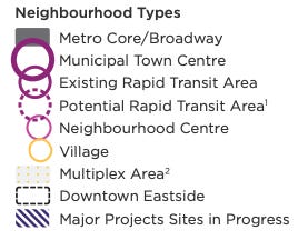
The Vancouver Plan’s version of neighbourhoods
So where was…Marpole? Dunbar? Grandview Woodland? All gone? Askance, I decided to use word search to help me. I was momentarily relieved to find 257 occurrences of neighbourhood in the Plan, so I started a methodical search from beginning to end.
What I found was a preliminary indication of what city staff really think of neighbourhoods. The Plan:
Says Vancouver is known for its beautiful natural setting, strong economy, diverse communities and vibrant neighbourhoods (p. 8)—so far, so good;
Talks of under-utilized neighbourhoods without naming them (p. 9)—we can guess, I guess;
Mentions pop-up neighbourhood events without naming the neighbourhood they occurred in;
Talks of equity engagement sessions held in the Downtown Eastside, Chinatown, Strathcona, Hastings-Sunrise, Kensington-Cedar Cottage, Collingwood and Sunset (p.20)—one wonders how this will be possible in future when these neighbourhoods will all be gone?
Talks of youth engagement at various neighbourhood houses (p.20)—I wonder if these will keep their legacy names after neighbourhoods are all gone?
Has a vision statement on p. 22: “Vancouver is a city that lives in greater balance with our ecological systems while providing more complete, inclusive and resilient neighbourhoods where people of all ages, incomes, abilities and backgrounds thrive.” Excellent! Neighbourhoods are still in the mix!
Proclaims on p. 25 one of three Big Ideas called “Equitable Housing and Complete Neighbourhoods.” This is further explained as “Allowing more housing options and opportunities for everyone to choose a livable neighbourhood that meets their needs. Ensuring all neighbourhoods have the things that matter most.” Again, a nameless concept when there are no named neighbourhoods.
This is nuts! I’m only 1/8th through the 257 neighbourhood references in the Plan, getting nowhere. I know! Instead of searching the generic word neighbourhood, let’s search the names of the neighbourhoods. Results are listed below in alphabetical order by neighbourhood name. We’ll ignore where the neighbourhood name is simply used in the caption to a photograph:
Arbutus Ridge—nothing
Downtown—p. 95, “Ensure capacity for growth in office space and hotels in Business Districts such as Downtown and Central Broadway and support them with services and amenities such as childcare, daily needs such as groceries, dining options and an improved public realm.”
Downtown Eastside (DTES)—this is Vancouver’s 23rd neighbourhood, separated from Downtown by some but not others. P. 99, “Continue to implement the Downtown Eastside Community Economic Development strategy”—nothing new here. The Land Use Strategy Map on p. 55 and the Technical Composite Map, p. 161 (more about that later) draws a boundary around the DTES
Dunbar Southlands, Fairview, Grandview Woodland, Hastings Sunrise, Kensington Cedar Cottage, Kerrisdale, Killarney, Kitsilano, Marpole, Mount Pleasant—nothing
Oakridge—success at last! The Land Use Strategy on p. 54 says “Municipal Town Centre (MTC): Second only in regional importance to the Metro Core/Broadway area, Oakridge MTC has excellent access to rapid transit and will support a dense mix of housing, jobs and amenities.” Direction L.1.4 (pp. 58-59) provides some details about how the Oakridge area plans will continue to be implemented.
Renfrew Collingwood, Riley Park, Shaughnessy, South Cambie, Strathcona, Sunset, Victoria Fraserview, West End, West Point Grey—nothing.
What does this all mean? Staff has used our existing 22-neighbourhood system when it suits the Plan’s words, especially the feel good word, neighbourhood, but is silent about all but two of the existing neighbourhoods—and those two are the highest density areas of the city.
As the Vancouver Plan moves to first position in the longish list of planning efforts that staff want the existing Council to endorse before the next civic election, I am moved to ask:
Were neighbourhoods told the Plan would eliminate them?
Were neighbourhoods told every one of them would be expected to absorb huge increases in population with no additions to schools, parks, community centres or other amenities?
Were neighbourhoods told that spot rezonings would be the go-to means to increase density everywhere in the city, with the associated disruptions?
Call to Action
For those citizens currently sitting on the sidelines, thinking “it doesn’t affect me,” know that the Vancouver Plan, which covers the entire city, will write the Broadway Plan’s high density concepts onto every quiet corner of every city block, every treed hill in every park, every close and distant vista in our decreasingly fair land. Please review the Vancouver Plan. If you agree with it, say so. If you disagree with it, or as with many, don’t understand it, say so. You must do so before the Plan comes before Council on July 6th. Not much time but the schedule is set by the Mayor and city staff for their convenience, not ours. There is no compelling reason for it to be considered before the next civic election.
Vancouver’s civic election is October 15th of this year. Lots more damage can be done to our city before that date—and it will continue, and worsen, unless TEAM for a Livable City elects a majority (6 of 10) City Councillors—less than 6 and not much will change. If you are concerned that what you’ve just read is an example of what’s wrong with our city, and want to bring back its livability, join TEAM and work with us to restore Vancouver as a place we can all afford to call home.
Today’s question: Do you like the Vancouver Plan? Why or why not?
I read and respond to all comments made below. If you enjoyed this post, consider becoming a free subscriber to City Conversations at
I am a Vancouver-based architect, building envelope and building code consultant and LEED Accredited Professional (the first green building system). I am semi-retired for the moment, still teaching and writing, so not beholden to any client or city hall. These conversations mix real discussion with research and observations based on my 40+ year career including the planning, design and construction of almost every type and scale of project. I am the author of the award winning Amazon best seller “An Architect’s Guide to Construction.” I am also a member of TEAM for a livable Vancouver, a new political party dedicated to restoring a livable Vancouver starting with the 2022 civic election. Although I am not a candidate for TEAM or any other civic party, City Conversations are generally congruent with TEAM policy, so if you like the ideas that I’m writing about, please consider joining TEAM.
we were declared a heritage area ( Shaugnessy) with strict building codes being applied and strict guidelines that were to preserve our heritage landscaping. one of the owners of Onni .. a huge property development company has had approved by city council ripping out three of its neighbours beautiful 80 year old landscaping and in our case, replaced it with a black chain link fence ( for their security) They we’re able to do this because the old property lines set in 1908 were not completely accurate in some parts and were approx 2 feet out. In 2 years we have not been able to get any sort of help or information from city hall about how we can preserve our ‘heritage’ look . We lost approx 25% of our home value because of the restrictions applied in order to preserve our heritage area, however when a big property developer buys, none of the same rules apply , they can destroy rather than comply . I wonder what city councillors and permit departments get from developers that they can have such immunity to the same rules as regular home owners?
Sadly Our city has become a kind of international cooperation and its beauty is a great selling point , alas, I dont feel the local city people have much control, perhaps some super person or people will slow the title wave and get the powers to be to take their tower building stuff to somewhere else, what will be ,will be