


Antisocial Housing
CC #160—Vancouver's Social Housing Initiative is neither social nor affordable


Where Vancouver’s 1% live—would this ever be social housing?—photo by Brian Palmquist
Glutton for punishment that I am, I attended the second of three in-person presentations of the city’s Social Housing Initiative (SHI) at the Kerrisdale community centre—you may have missed it if you blinked. I have written about SHI before.
Like all of these, it was held from 5 to 7pm, when most of us are having dinner. Having read the SHI as well as the underpinning Vancouver Plan (VP) and the Housing Vancouver Strategy (HVS), I came armed with just a few questions. I was eventually referred to the most senior of the three (yes, just three!) city staff answering questions from the public. As with all these events, no staff had a notebook of any kind—I guess they just remembered all of our input. But for the record, here’s what I asked and heard:
My question #1: How did the SHI zoning diagram arise and how does it relate to…well…anything?
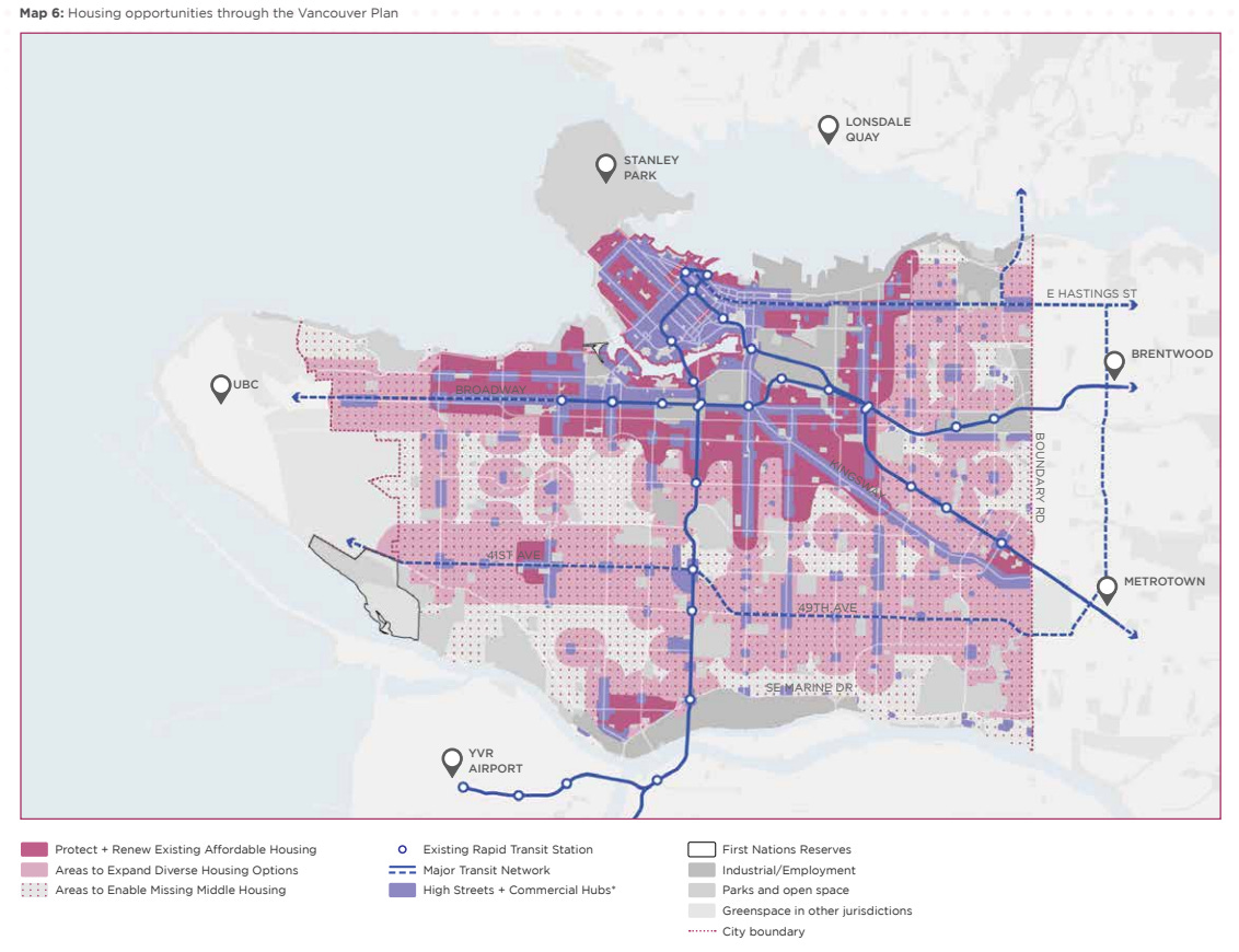
Vancouver Plan Housing Opportunities1
Neither the Vancouver Plan nor the Housing Vancouver Strategy explain how the Vancouver Plan’s various coloured proposed zoning blobs shown above morphed into the SHI diagram shown below. In fact, Board 18 asks and answers why the two maps are different, just not in clear terms that I can follow:
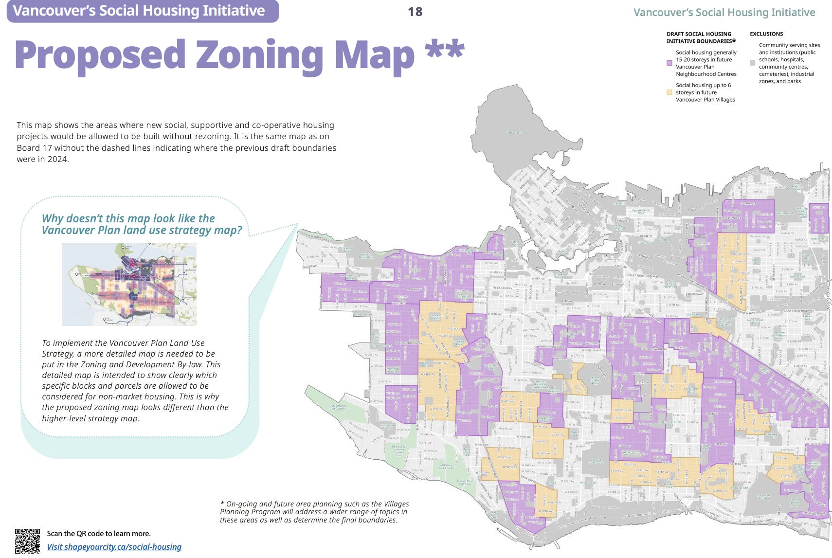
Proposed social housing zoning2—orange is up to six storeys, purple is 15-20 storeys
Of perhaps greater importance than the unexplained leap3 between the Vancouver Plan and the SHI plan is how the coloured patches ignore all of the schools, parks, high streets and most other community spaces in the patched areas. The Project Lead explained that future specific policies and details would cover off issues such as shadowing of those nonresidential uses, proximity of residents with mental health and addiction issues to schools, etc. I suggested that many Broadway Plan approved and proposed rezonings include shadowing and proximity issues, offering that it would not be that difficult even at this stage to identify exclusion zones as well as areas where the purple should be orange to avoid overshadowing public amenities. This suggestion was rebuffed.
My question #2: How did we get to 18-20 storeys for social housing?
There is ample research in many countries over many decades that supports the positive aspects of housing up to +/-six storeys4, the height proposed for the orange patches. There is even more research suggesting living above 6-8 storeys is bad for seniors and families, especially those with low income5. The Project Lead indicated that there are post occupancy surveys supporting high rise social housing—I am following up on that with them, will report what I find in a later CC. So far, all the research I’ve found says 18-20 storeys is pretty antisocial for seniors, lower income families and folks needing support. Just sayin’.
My question #3: Why are buildings identified in storeys rather than overall height?
During my decades of designing thousands of affordable rental, co-op and strata homes, every project had eight foot (2.4m) ceilings, resulting in nine feet (2.75m) maximum as a floor-to-floor height6. Greater heights just increase costs, i.e., reduce affordability.
The Project Lead assured me that these things would be dealt with in later regulations:

What the SHI says about building heights—Board 24
Those of us who have been analyzing Broadway Plan rezoning proposals must report:
Tower spacing is regularly reduced for no reason other than permitting more towers.
Many rezoning proposals have inaccurate (misleading?) shadow studies that mask overshadowing of public amenities.
Most rental rezoning proposals have 3m (10 feet) floor-to-floor heights, resulting in buildings that are 11% higher7 than they need be.
Any future district schedule with maximum building heights more than (2.75meters x number storeys + 1meter for lobby extra height at grade and 1 meter for roof parapets) will be excessive and unaffordable for social housing. Period.
My question #4: What’s the “social housing = 30% social housing” deal?

City staff’s definition of social housing for the 30% on Board 6
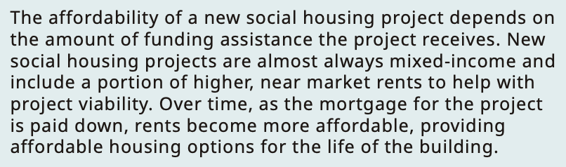
City staff’s explanation of need for “near market” rents for the 70%, also on Board 6
We are just now starting to see the rents for “near market” apartments in projects with a proportion of social housing. Here’s the first example:
Rents for the smallest studio starting at $2599 per month.
One bedroom rents starting at $2,999.
Two bedroom rental starting at $3,999.
I won’t comment on the apartment layouts beyond saying they are mostly unlivable.
My conclusions based on what’s been presented and my cursory research:
There is scant justification for the locations of social housing orange and purple patches.
Not already carving out areas adjacent to, shadowing and/or intruding on public amenities is just lazy and will lead to further mistrust in the absence of public hearings.
Allowing floor-to-floor heights more than 2.75m (9 feet) is contrary to affordability.
The 70% of homes that are not real social housing will have rents unaffordable to most of the folks regularly trotted out by politicians as needing affordable housing—starting teachers, nurses and firefighters will pay way more than 30% of their starting salaries.
I urge you to check out SHI, and review the SHI before its July 8 deadline. Emailing your thoughts to City Council is also a good idea.
This post is just under 900 words, much more than the 3-5 minutes citizens are allowed when they speak to the current City Council, in their efforts to suppress democracy. If you appreciated it, share to your social media and consider becoming a free subscriber to City Conversations at

Brian Palmquist writes on the traditional, ancestral and unceded lands of the Musqueam people. He is a Vancouver-based architect, building envelope and building code consultant and LEED Accredited Professional (the first green building system). He is semi-retired, still teaching, writing and consulting a bit, but not beholden to any client or city hall. City Conversations mix real discussion with research and observations based on a 50-year career including the planning, design and construction of almost every type and scale of project. He is the author of the Amazon best seller and AIBC Construction Administration course text, “An Architect’s Guide to Construction.” A glutton for punishment, he recently started writing a book about how we can Embrace, Enhance and Evolve the places where we love to live. Some of its content may appear above.
https://vancouver.ca/files/cov/vancouver-plan.pdf page 51
https://syc.vancouver.ca/projects/social-housing/vancouver-social-housing-initiative-updated-boards.pdf Board 18
I had a specific discussion with the city’s “Project Lead” for the SHI project about this leap—they had no explanation beyond not wanting to confuse the public with too much information.
Too many sources to cite for +/-6 storeys, my favourite observation is that above about 6 storeys you can’s make out the faces of folks above or below, disconnecting the street from its residents. This one is interesting in relation to highrise living: https://buildingtheskyline.org/highrise-living/ does indicate that high rises can be positive living environments, just not at prices most folks can afford. Google “psychological issues with high rise housing” for dozens of studies.
https://pmc.ncbi.nlm.nih.gov/articles/PMC3456225/ includes this in its abstract: “Highrise housing is inimical to the psychological well-being of women with young children.”
As the name suggests, floor-to-floor height is the dimension from the floor of a storey to the floor next above or below.
9 feet/8 feet = 11%
Thanks for applying your knowledge to this initiative, Brian. It's hard for laypeople to grasp what the heck the city is doing. The maps are super-confusing. Took me awhile to understand that the purple/orange one is where rezonings and public hearings won't be required, while the giant pink one that you didn't mention means SHI applies to virtually the whole city (but with rezonings required). What happens to all this when the Official Development Plan is passed next year?