


What’s at stake in Riley Park & South Cambie
City Conversation #76: two neighbourhoods that work together—does the Vancouver Plan work for either?

September 2nd 2022—2nd in a series about what the recently approved Vancouver Plan means for each of the city’s 23 existing neighbourhoods.

The Vancouver Plan view of Riley Park & South Cambie neighbourhoods—neighbourhood boundaries in red added by me
“What’s the dark area at the top and bottom of this diagram,” asked my son as he looked at the first of my neighbourhood Vancouver Plan analyses. “And why does a red border line run vertically on the centre left?”
“At a community level, these two neighbourhoods have a long history of collaboration. I made a presentation to them in April of this year and that’s the way they wanted to do it. So it seemed logical to look at them together.”
“So tell me a bit about that history,” he asked.
“In some ways they are very different. While Vancouver’s overall population has increased less than 5% in the past five years, South Cambie’s (left of the centre red line) has increased more than 20%, mainly because of the influence of all the development along the Cambie Corridor. Riley Park’s population has only increased a bit more than the overall city’s 5%.”
“So let’s come back to these smudgy colours—what do they mean?”
I focused on the plan. “The Vancouver Plan only identifies five different neighbourhood types. That’s not to be confused with an existing neighbourhood, of which Vancouver has 23.”

The Vancouver Plan’s Five Neighbourhood Types
I continued. “Four of these five neighbourhood types occur in Riley Park & South Cambie:
A Municipal Town Centre (MTC) is at the bottom left—Oakridge, which the Plan describes on Page 40 as Low-rise, mid-rise and high-rise multi-unit buildings generally up to 25+ storeys. Minimum density: 60–200 Jobs + People/ hectare. Kinda sounds like Oakridge.
A Rapid Transit Centre runs along Cambie from 16th Ave south to Queen Elizabeth Park—that’s the colour I don’t know the name of, centred around King Edward and Cambie. The Plan describes this as Low-rise, mid-rise and high-rise multi-unit buildings generally up to 12–18 storeys. 25+ storeys in strategic locations. Corridor: 35-80 Jobs + People/hectare Station Area: 60-350 Jobs + People/hectare.
Neighbourhood Centres run down Main Street from 16th Ave south to somewhere south of 33rd Ave. The Plan describes this as Low-rise and mid-rise multi-unit buildings generally up to 12 storeys. Minimum residential density: 40-60 People/ hectare.
Right below the neighbourhood centre on Main is a village centred around 41st and Main, which the Plan describes as Low-rise multi-unit residential and mixed-use buildings generally up to 6 storeys. Minimum residential density: 40 People / hectare.
Finally, there are a few left over light coloured bits called multiplex, which the Plan describes as “Primarily ground-oriented residential including single, duplex and multiplex dwellings. Up to 6 storeys for rental or social housing where the Secured Rental Policy (SRP) applies.”
“The names of these neighbourhood types seem unthreatening—what do they actually mean?” asked my son. “I’m familiar with Oakridge—what do the rest mean?”
“Let’s start with the least dense—multiplex areas.” He shrugged so I continued. “Multiplex is defined in the Plan as a new type of ground-oriented housing as a similar but more affordable and sustainable option to single-detached homes.“
“Sounds innocuous enough—what does it look like?” he asked, so I answered, pointing him to the Plan’s diagram:

Multiplex illustration from page 67 of the Vancouver Plan
“That’s a pretty wide range of housing types,” he commented after looking at the image for a few moments.
I responded, “Yes, but I have a hard time disagreeing with it, at least in principle. However, it only comprises about 10% of these two neighbourhoods.”
I continued. “The next most dense neighbourhood type is a village, of which these neighbourhoods appear to have just one centred around Main & 41st Ave. Again, I have a hard time being upset at this description, even if it allows up to six storey buildings.”

Village illustration from page 65 of the Vancouver Plan
“Next we have the neighbourhood centre type of neighbourhood, which runs down Main Street from 16th Ave south to somewhere south of 33rd Ave.”

Neighbourhood Centre illustration from page 63 of the Vancouver Plan
“Here’s where the first real surprise (for me) arises. That blue line marked frequent transit can only be Main Street.” He nodded agreement so I continued. “Notice the higher, lighter blue buildings located a block or two off Main?” He looked surprised but nodded agreement. “I was a bit surprised, so looked for an explanation, found this diagram later in the Plan:”

Page 71 of the Vancouver Plan—let’s move the high-rises into the side streets
“Even though I have an urban design background, it took me a few minutes to figure this out. What it means for Main Street from 16th to 33rd Avenues is that, in fact, there could be up to 12-storey high-rises along that length, but from James or Quebec Streets to the west, as far to the east as Sophia.”
Not being familiar with that part of the city, he shrugged. I decided to bring it closer to home. “You grew up 1-1/2 blocks west of Dunbar Street, which is also a neighbourhood centre under the Vancouver Plan. So we could have a 12-storey high-rise next door to us under this Plan!” At that he raised his eyebrows and asked, “Why would anyone propose that? Why not along Dunbar? Or Main?”
“The planner’s desire appears to be to avoid shading shopping streets with high-rises. So the simple solution is to shift them east or west—presumably the lower density homeowners in those areas don’t mind the shade and overlook.”
I continued. “But we’re not done yet! We still have a rapid transit centre along Cambie from 16th Ave south to Queen Elizabeth Park.”
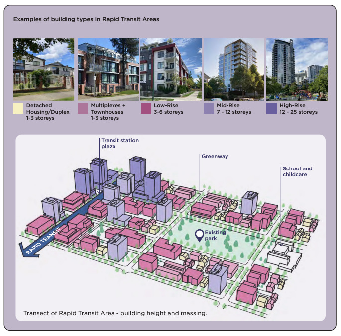
Rapid Transit Centre illustration from page 61 of the Vancouver Plan
He stared at this diagram for a few moments. “I see a few things different from the neighbourhood centre. There are some taller buildings and the lower high-rises extend further from the rapid transit line. There’s also an existing park, a greenway, a school and childcare—all good!” He smiled at his observations.
“I agree, all good.” I paused to gather a bit of steam. “But here’s the rub. There is only one existing public elementary school, Simon Fraser Elementary north of 16th Avenue, and one english language high school, Eric Hamber, in the southwest corner of these neighbourhoods.”
He interrupted, “Surely the city and province will build more schools for all this new population?”
“Tell that to the folks in the Olympic Village who were promised a school but have nothing after more than a decade. Heck, tell that to the folks in South Cambie who’ve had four times as many folks move in over the past five years as the Vancouver average—with no new schools or parks. There is no site for a school identified in these neighbourhoods— the word school is mentioned more than 40 times in the Vancouver Plan, but without any new sites the word becomes meaningless.”
“So,” he moved to summarize, “what you’re saying the Vancouver Plan means for Riley Park and South Cambie is: much higher density pretty much everywhere; no new schools; and high-rises marching along the edges of Main Street but not actually on it.” He paused for a moment. “That part along Main kinda sounds like the Broadway Plan, doesn’t it.”
A Reader comment
While I was still writing this I received a comment about a previous City Conversation from a person who has been demovicted on multiple occasions from shared homes in the Riley Park and South Granville neighbourhoods. I include an excerpt here to remind us of other perspectives:
“I didn't see the Cambie Corridor listed in the mega projects - May have missed it but figured I would mention.
I feel like all the powers that be debating about the fake numbers, and zones and labels like strata, secure, Market, secondary, affordable Market, below market, supported, subsidized, SRO...etc. and following all these label is "Site" so it is easy to forget that what needs to be discussed accounted for are not zones, lots, and not just to be sold and bought we need homes for people. All sorts of people- not just rich people. What the city planners need to be held accountable for is planning and prioritizing providing the housing we have so desperately needed for so long.
Sustainability and supporting the communities that are the heart and hope of the City needs to be a priority too. Listening and being guided by the input of the people who are in need of homes- To live in not just to profit from. As wells as the communities of people that love the place they live and are invested in how their neighbourhood is going to be developed and the people who want and need to be apart of a community and have safe and affordable housing to live in.”
The Time for Action will soon be too late
Please let me know what pre-election activities are happening in your neighbourhood—I will try to order my neighbourhood-based analyses to have maximum impact.
TEAM for a Livable Vancouver is the only political party pledged to set aside the Vancouver Plan and the related Broadway Plan. Vancouver’s civic election is October 15th of this year. Lots more damage can still be done to our city before that date—and it will continue, and worsen, unless TEAM elects the next Mayor and a majority (6 of 10) City Councillors—less than 6 and not much will change for the better. A majority TEAM Park Board (4 of 7) will ensure our open spaces are integrated with the city rather than ignoring or fighting it. If you are concerned that the City Conversations you’ve been reading are examples of what’s wrong with our city and want to bring back Vancouver’s livability, join TEAM and work with us to restore Vancouver as a place we can all afford to call home.
And please let me know what other subjects you are passionate about so we can have that conversation before election day, October 15th.
Today’s question: Do you like what’s proposed for your neighbourhood? Why or why not?
I read and respond to all comments made below. If you enjoyed this post, consider becoming a free subscriber to City Conversations at
Brian Palmquist is a Vancouver-based architect, building envelope and building code consultant and LEED Accredited Professional (the first green building system). He is semi-retired for the moment, still teaching and writing, so not beholden to any client or city hall. These conversations mix real discussion with research and observations based on a 40+ year career including the planning, design and construction of almost every type and scale of project. He is the author of the Amazon best seller “An Architect’s Guide to Construction.” He is also a member of team for a livable Vancouver, a new political party dedicated to restoring a livable Vancouver starting with the 2022 civic election. City Conversations are generally congruent with TEAM policy, so if you like the ideas that I’m writing about, please consider joining TEAM.
Mr. Palmquist,
For the City Council sessions (July 6 & 22), I sent in a comment in which I noted that the Vancouver Plan does not indicate "Cambie Village" on any of their maps.
Cambie Village, as defined and described in Section 4.1 (pages 38 through 47) in the Cambie Corridor Plan (May 2018), extends along Cambie from 16th to 25th (King Edward Avenue).
In an email (which failed to go through), I attempted to send three screenshots taken of pages 38, 40, and 44 of the CCP document. Because I could not attach them to this comment, I simply refer you to those pages in the CCP document. Please note that, for the apartment buildings that line Cambie between 19th and 24th Avenues, the CCP states the following:
The existing RM-3A zoning will be retained to preserve this stable rental housing.
The proponents of the Vancouver Plan either are ignorant of, or chose to ignore, what is in this City document.
If Council or Staff members are ignorant of the contents of the CCP, then they should be alerted to this discrepancy (as I attempted to do in my comment to Council).
If Council or Staff members chose to ignore the contents of the CCP, then when can residents rely on any City-issued document?
Thank you.
Regards,
Veronica Yakoleff
• Member of the Riley Park—South Cambie Community Group
• South Cambie Resident (Renter at 21st and Cambie)
I appreciate your analysis - can't get this level of detail anywhere else, certainly not from media. Question, however. You urge support for TEAM Vancouver in the municipal election. You say that TEAM will not carry through with the Broadway or Vancouver Plans. What would TEAM do instead, to address housing affordability and climate change?