
Jericho Lands + UBCx UPDATE—Time is of the Essence
City Conversation # 38: How the UBC SkyTrain extension and the Jericho Lands proposals help each other—but nobody else

March 27th, 2022—When I first wrote about the proposals for Jericho Lands five months ago, it appeared there was lots of time to think about which of two alternative site plans worked best, where buildings were or were not proposed to be placed and how tall they might be. But as so often happens with this city management and Council, things are suddenly moving much more quickly than the relaxed planning schedule suggested. Time for an urgent update:
Call to Action—These usually come at the end of my City Conversations, but the Jericho Lands Plan is such a key element of the city’s proposal to extend SkyTrain to UBC, which is coming to City Council for review and perhaps approval Tuesday, March 29th that your action is needed NOW. Please write to Council directly, BEFORE Tuesday, better yet, speak to Council in person or by phone. If you wish to speak, the deadline to sign-up is March 29th at 8:30am—the meeting itself starts at that time. The sign-up form is all online, but the timing is fixed.

Jericho Lands Concept Plan viewed from the Northeast (Jericho Park at the lower right) —model images courtesy Stephen Bohus, BLA and Kunal Tiwari, MUD, MLA, BCSLA Intern
“Dad, are you sure that’s correct?” My son was looking over my shoulder at an aerial view of the current proposal for the Jericho Lands (JL). “Surely it’s not that massive?”
“Depends on who and what you trust,” I answered. “Five months ago, when the JL plans were first revealed to the public, I transferred some building heights from the proposal documents to the favoured site plan:”
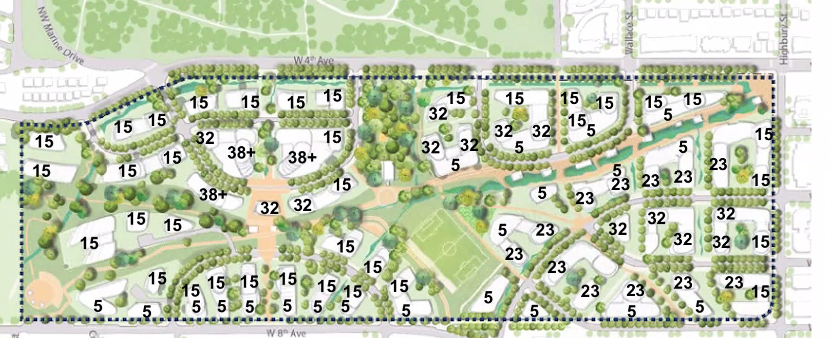
“Eagle” concept plan —maximum building heights in storeys added by Brian Palmquist
“So what are all the numbers?” he asked.
“Those are the proposed building heights in storeys—they range from five to more than 38 storeys—more than 60 of the proposed buildings are 15 storeys or more. When you model them out, you get the aerial model photo on my screen.”
He paused to study the plan, asked, “So how many apartments is that all together?”
“Well,” I answered, “that information is not stated yet, but I’ve made an educated guess.”
“Why isn’t that information tabled with the plan?” he asked, looking puzzled that such basic information was missing.
“I was as puzzled as you are. I was Managing Architect for the Official Development Plans (ODPs) of two major developments, False Creek North and Coal Harbour, and all of our presentations from very early on included exact proposed housing counts, and their building areas and heights, as well as the size of all commercial and community facilities.” He nodded at the sense of that.
“But in this case, documentation suggests about 10,000 apartments and a population of about 18,000 people—a lot for the area, but a starting point.”
“And what do your calculations show?” came his quick question.
“Well, to make an educated guess, I first had to look at the plan documentation’s blobby diagrams of building heights and translate them into likely building heights in storeys.” He kept staring so I kept going. “I checked the floor plans of three current high-rise residential projects along Broadway—one at Alma Street and Broadway, one at Granville Street and Broadway, and a final one at Birch Street and Broadway. These are very different buildings, with different designers and builders, but the average floor on these three buildings has 10 apartments, so I used 10/floor as my guide. That way I could just multiply the number of storeys times 10 to get an estimate of the number of apartments.”
He nodded understanding, noting: “Crazy that you have to do those calculations, but they make sense. What are the results?”
“Well, the planning documents talk about 10,000 apartments and 18,000 residents. I used the city’s average of 2.2 people/apartment, more than their 1.8/apartment, and I came up with 14,510 apartments and almost 32,000 residents.”
“Why are you using a greater number of inhabitants per apartment than they are? Your 2.2 versus their 1.8?”
“Good question, son,” I answered. “The city planners have used 2.2 for some time. There’s no explanation for their 1.8 number being almost 20% less than what their own folks have been using, so I stayed with 2.2. One explanation might be that they are expecting a large preponderance of apartments to be smaller, say studios and one-bedrooms.” He frowned at that, knowing how tough it is for families to find housing and how close the site is to Queen Mary Elementary School.
“Seems weird,” he continued. “And how about the unit counts, their 10,000 versus your 14,500+?”
“A friend of mine was also curious about that, so asked the city’s planners in charge about the discrepancy.” He smiled slightly, happy others had noticed this additional discrepancy. He was not happy with my response.
“The planners explained to my friend that although the site plan illustrated much more housing than their notional 10,000—notional meaning it’s not a firm cap or limit—they would not permit, say, one building to be built higher without another later building being built lower.”He stared with knitted brows so I continued.
“Yes, I also find that a weird concept. When we planned False Creek North and Coal Harbour, building heights and quantities of apartments were clearly stated. The idea of hoping that a later building would be lower because an earlier one was higher is no way to plan a development of this size—the last several years of development in the city are rife with the opposite example. Not just the many spot rezonings, but ODPs and Area Plans such as the East Fraser Lands, Oakridge, the Pearson/Dogwood Development—all have involved apartments and storeys added, seldom reduced.”
“Correct me if I’m wrong,” he interjected, “but it seems like that whack-a-mole game, where you whack one block down and another pops up!” I laughed at his simile. He didn’t, instead continued with a renewed frown.
“I can’t believe we’re looking at anything less than the real build out of the project, not some plan where anything will get smaller over time.” I nodded agreement. “So what does this development look like from the ground? Nobody will see what it’s like way up in the air like you’re showing.”
“The city won’t give access to the 3-D models they developed for the project, so we developed our own. Let’s start with what you’ll see when you park your bike to go to the Folk Festival and look back toward the south:”
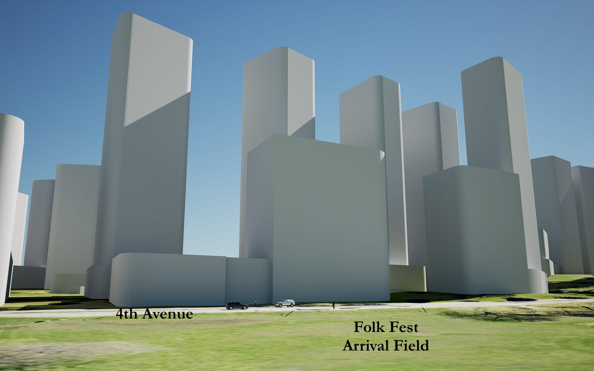
Looking South across 4th Avenue from the Folk Festival Bike Parking Field
“Dad, how tall are those buildings? The cars make them seem huge!” he asked, incredulous.
“It’s all accurate—the little building to the left is five storeys. The short wall marching to the right is 15 storeys tall, the second row is 32.”
He continued to look closely. “That feels like a wall along 4th Avenue—have I got it wrong?”
“Unfortunately,” I answered, “that’s exactly what’s proposed. You’ve not been to New York City, but it’s much like the buildings for the wealthy that line their Central Park.”

Looking West along 4th Avenue
He gulped. “What about from above? What does it all look like from the Park next to Queen Mary?”

View from Trimble Park looking Northeast
“I asked the 3-D modellers to pull back from the park to across the street, otherwise there was no context,” I explained. He glowered at me. “By context, do you mean that bit of mountain at the left? Looks like if you were standing in the park itself you’d never see the mountains.” I nodded reluctant agreement.
“So,” he continued, “you’ve shown the other edges of the development—what’s happening along Highbury Street at the eastern edge?”

View from Northeast Corner of Highbury (at left) and 4th Avenue (to the right)
I didn’t wait for his questions. “There’s a quartet of 15-storey buildings marching along Highbury, then turning the corner at 4th Avenue and winding through the centre of the development.”
“What’s the lower building mass that appears almost continuous, joining the high-rises?”
I replied, “Those are the short, five storey buildings—they’re only a bit taller than most of the buildings in the neighbourhood.”
He thought for a few moments, then asked, “How are these 32,000 new residents going to get around? Am I right, that’s about double the existing population of West Point Grey?” I nodded. “TransLink is cutting bus service all over the place—what’s going to make this work?”
I smiled weakly. “That’s the punch line. The city is set next Tuesday to endorse extending SkyTrain west from Arbutus along Broadway, all the way out to UBC. Somehow, all the folks living here are expected to leave their cars at home and take SkyTrain everywhere…I guess.”
“But Broadway is the south edge of this development—how does that work?”
“Magically, it appears the SkyTrain extension will bend at Broadway and Alma so it stops in the middle of this development.”

He interjected again, “But then it’ll come back up to stop in West Point Grey Village, right? That would help the Village, which has suffered since Safeway left.” He looked pleased at this deduction.
“Actually, no,” I responded, “the city’s own plan shows SkyTrain stopping in the middle of the Jericho Lands, then continuing nonstop out towards UBC.” He looked incredulous. “But won’t that kill the West Point Grey Neighbourhood?”
“I guess they just don’t have the millions to pay for a neighbourhood stop.” I paused for effect. “They can always grab the 99B-line bus, I guess. Oh wait! It won’t be running anymore.”
Remember, you only have until 8:30am March 29th to sign up to voice your opinions about the UBCx Skytrain extension.
More Calls to Action
Opposition to the current proposal for the Jericho Lands is being led by the Jericho Coalition, a group of concerned citizens, many of whom participated in the three year long “consultation” process and feel betrayed by the emergent plan, which they did not see until the eve of its publication. There may be other groups I am unaware of. If you are also concerned about the Jericho Lands Plan, consider joining them.
Vancouver’s civic election is in mid October of this year. Lots of damage can be done by the current Council, city management and staff before that date—and it will continue, and worsen, unless TEAM for a Livable Vancouver elects a majority (6 of 10) City Councillors—less than 6 and not much will change. If you are concerned that what you’ve just read is an example of what’s wrong with our city, and want to bring back its livability, join TEAM and work with us to restore Vancouver as a place we can all afford to call home.
Today’s question: Do you think any SkyTrain extension to UBC should include a station in West Point Grey Village? Why or why not?
I read and respond to all comments made below. If you enjoyed this post, consider becoming a free subscriber to City Conversations at
Brian Palmquist is a Vancouver-based architect, building envelope and building code consultant and LEED Accredited Professional (the first green building system). He is semi-retired for the moment, still teaching and writing, so not beholden to any client or city hall. These conversations mix real discussion with research and observations based on a 40+ year career including the planning, design and construction of almost every type and scale of project. He is the author of the Amazon best seller “An Architect’s Guide to Construction.” He is also a member of team for a livable Vancouver, a new political party dedicated to restoring a livable Vancouver starting with the 2022 civic election. City Conversations are generally congruent with TEAM policy, so if you like the ideas that I’m writing about, please consider joining TEAM.
More than 3,000 people have now viewed this post—a record for my City Conversations and I am told a more than respectable audience in any forum. Thanks to all for reading, and to many for responding so thoughtfully. There remains hope!
City Conversations needs an ANGRY button. There is absolutely no justification for this type of density in addition to the proposed density in the Broadway Plan. I thought the Safeway on 10th was torn down to provide a station for the yet to be approved skytrain extension. The arrogance of the City Planners is not to be believed. Thank you for keeping us informed.