It’s really hard to get accurate and up to date statistics on housing in Vancouver—even for Vancouver City Councillor Colleen Hardwick:
“I specifically asked for current data around housing in May of 2020,” she explained. “You would think this would be readily available, given all of the proposed rezonings going on in the city—apparently not! Eventually, city planning department staff committed to providing current information by the end of July 2020. On that day, we received a memo identifying an update on what housing targets the city aspired to meet. To be clear—no hard data, no spreadsheet of housing units added…nothing since 2016, in fact.”
Instead of hard numbers, which should not be hard to collect when you are city planning staff, we have instead an April 2019 “Annual Progress Report” listing a “target” of 72,000 new homes proposed for the city over the next decade. To be clear, no research, findings or other data is offered to support 72,000. That’s far higher than the 32,000 new homes required over the next decade (2021-2031) based on Metro Vancouver Regional Growth Strategy projections starting in 1986, just after Expo 86 opened the doors to rapid development. The difference is important because housing projections are being used as the basis for approval of many new developments currently coming before council:
Councillor Hardwick remains unable to obtain the data behind the 72,000 number that she requested ten months ago. Her concern is that the much higher number is being used to support approval of many spot-rezoned developments, usually high-rise, that are providing few, if any, affordable homes—meanwhile land speculation around these larger unit numbers is raising the cost of all land in the city, further damaging affordability.
What is fairly easy to identify is the amount of housing proposed by various megaprojects at various stages of development:
Before we look at alternative ways to get from these 18,000 megaproject homes to 32,000 units, let’s also remember that there will be a projected 4,000 laneway houses built in Vancouver over the next decade, in addition to those already constructed. Park that 4,000 for a few paragraphs.
Bear with me while I continue with a few more important numbers. As an architect with planning and urban design cred and frustrated at Colleen’s inability to get real housing data from city staff, I thought “How hard can it be to estimate what’s likely and what’s possible?” In the absence of any hard data from city staff, I developed my own methodology:
Get a three-dimensional Vancouver zoning map to compare what’s actually built against what’s currently zoned;
Identify what could be built under current zoning—no special deals, no debate over how high is too high?, etc.
Run the numbers.
Turns out Vancouver city hall has no 3-D map, unlike some other major North American cities. Fortunately, Robert W. White at https://nicholsonroad.com had exactly what I needed, perhaps slightly out of date but close enough for my purposes.
Now if you are a planner or architect you are already thinking “There are way too many zoning types to analyze,” and you would be correct. How to simplify?
Vancouver is laced through with ribbons of commercial development along various parts of major arterials: think (from East to West and running North-South, an incomplete list) Victoria, Commercial, Renfrew, Main, Cambie, Oak, Granville, Arbutus, Macdonald, Alma; then think the East-West main roads such as Kingsway, Hastings, West 41st, Broadway, 4th Ave., etc. The complete list is too long for here—you’ll have to trust me when I say I looked at all the relevant areas.
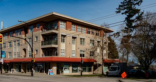
The planners reading this will know that the heart and soul of most Vancouver neighbourhoods is these “C” zones, with evocative names like “C2C, C2C1, C2A”—enough said. These are the areas that host the neighbourhood shopping and services essential to residents—food stores, barbers, liquor stores, restaurants, even pot shops. When redeveloped according to long-established zoning rules and guidelines, they usually result in three storeys of apartments above ground level shops—something we are pretty much all used to. One of many examples is the leadoff photo for this article.
Fortunately for my sanity, Robert White’s Vancouver zoning map shows all of these “C” areas in bright red. That made it easier to look at each of more than 200 blocks zoned for commercial activity—I’m sure I missed a few, which means my findings are conservative.
There is good news here:
I am not going to list all 200+ blocks I looked at, although I did take screen shots of all my calculations;
There is lots of what planners call “zoning capacity” available without any more mega projects—more than 11,000 new low-rise housing units can be added in “C” zones without breaking a sweat;
So, let’s do the math one more time: 18,000 units in already or as-good-as approved megaprojects + 11,000 “C” zone units + 4,000 laneway houses = 33,000 housing units, which is more than the 32,000 units we are projected to need;
These “C” and laneway projects would all be local and small—think two or three laneways to a block, or twenty units at a time in the “C” zones, to a maximum of 100 units in those rare locations where there is an entire city block standing empty. Many smaller projects designed by many architects for many small clients, built by smaller builders.
You’re thinking, “If it’s so easy, why hasn’t someone else done this analysis?” Five reasons:
It takes my 40+ years experience to be able to look at an underdeveloped city block and say, “This will easily accommodate thirty more homes.”
You have to simplify to keep your sanity—I only looked at “C” zones, which left out the entire downtown peninsula as well as neighbourhoods with really limited unused commercial density, such as Southlands, Killarney, etc. Again, this makes for very conservative findings;
You have to encourage incremental development in the “C” zones, such as we regularly see—three storeys of apartments atop shops at grade, on small individual lots rather than entire blocks;
You have to ignore the “noise” of current and planned spot rezonings—these are the curse of city planning and a huge rabbit hole—they also represent thousands of expensive housing units and very few even remotely “affordable;”;
You have to want to do this more than mega projects and high-rises.
So, what have I proved to myself, based on this simple, conservative analysis?
No more spot rezonings are necessary, including any currently underway, including any under construction—perhaps what’s currently under construction should be subtracted from other mega projects rather than from formerly low-rise neighbourhoods like the Cambie corridor and Marpole;
No more broad upzonings are necessary, such as contemplated along most of Broadway;
Established communities such as False Creek South can be maintained, with incremental modification rather than wholesale replacement and loss of existing affordable housing, open spaces, views, amenities, etc.
I’m sure I have missed some additional benefits—use your imagination.
I’ve run out of word count—the next instalment will look at how city hall might encourage the kind of incremental welcoming of new neighbours along existing neighbourhood shopping streets that I believe every Vancouver citizen is up for, instead of what’s currently on offer.
Brian Palmquist is an Architect, BC’s first accredited Building Envelope Professional, a Certified Professional and a LEED Accredited Professional. He was Managing Architect for the community planning phase of the North Shore of False Creek. More recently he introduced the laneway housing concept at the first ECOdensity forum. He is the author of the award-winning nonfiction book, “An Architect’s Guide to Construction—Enduring Ways in the Age of Immediacy.”


Excellent analysis Brian. I think the city should try to figure out what the demand is for each type of housing and try to target those type of homes. Price range, units size, number of bedrooms. Figure this out in a grid and start letting the development industry know what is wanted. Now that would be a “planning” exercise.
Update your report by providing the numbers from other projects like River District 128 acres, Pearson 57 and Cambie, OTC at 41st and Oak, Little Mtn at 35th and Main